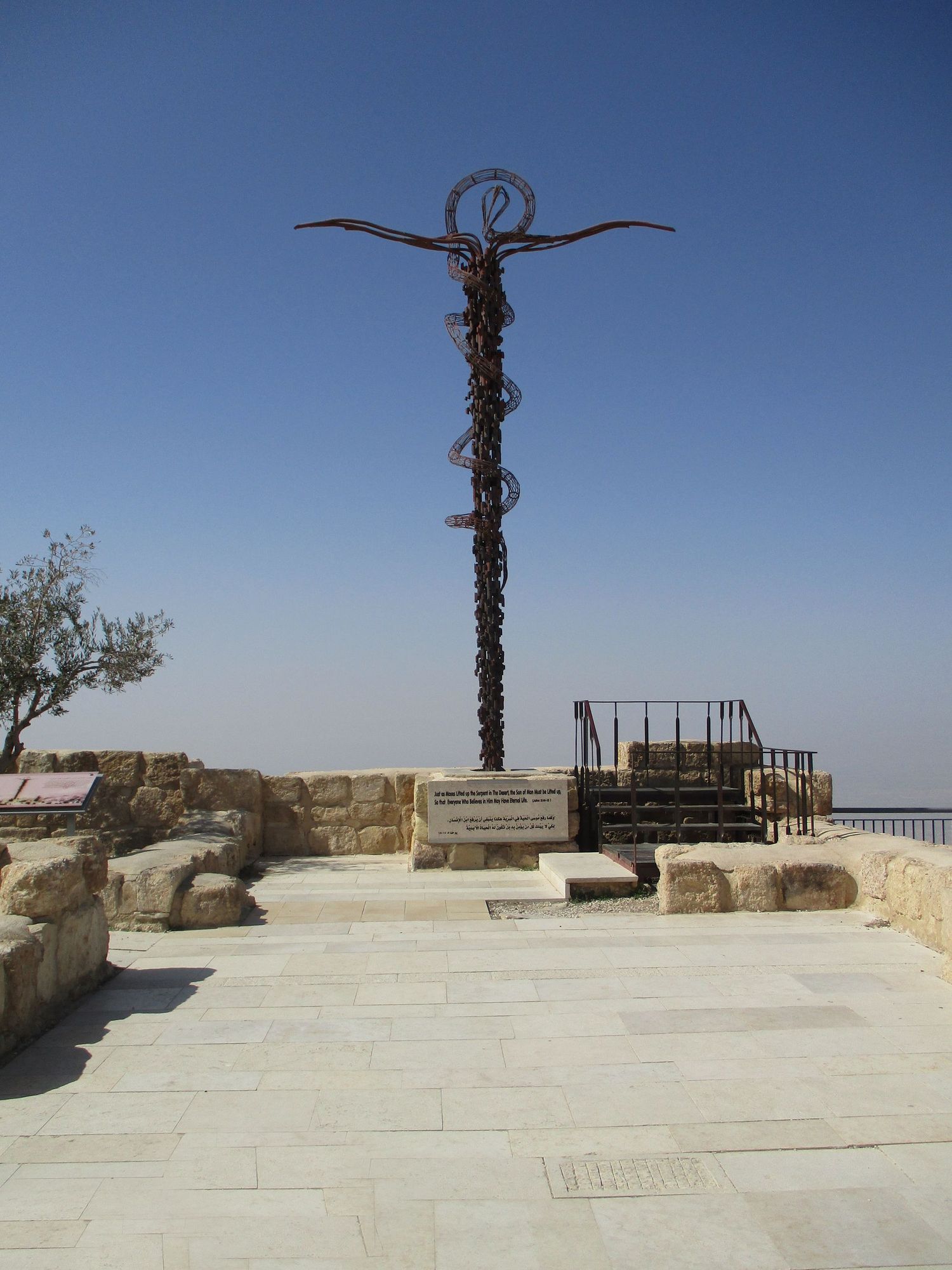
The Top of Mt. Nebo Where Moses Saw the Promised Land

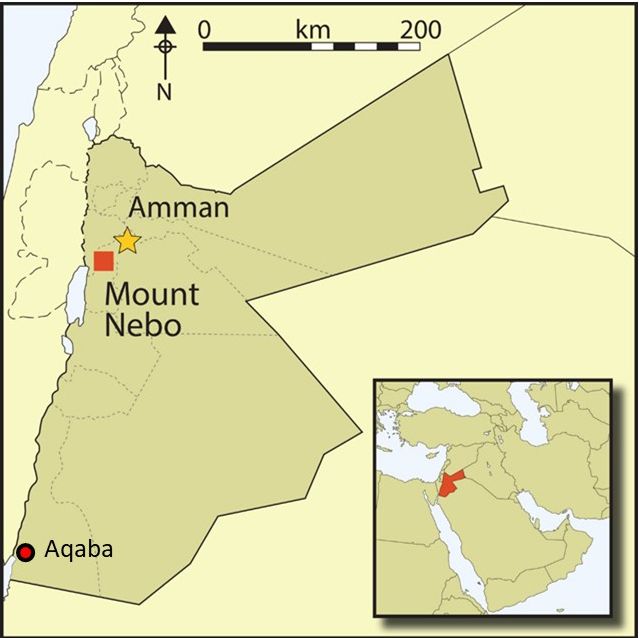
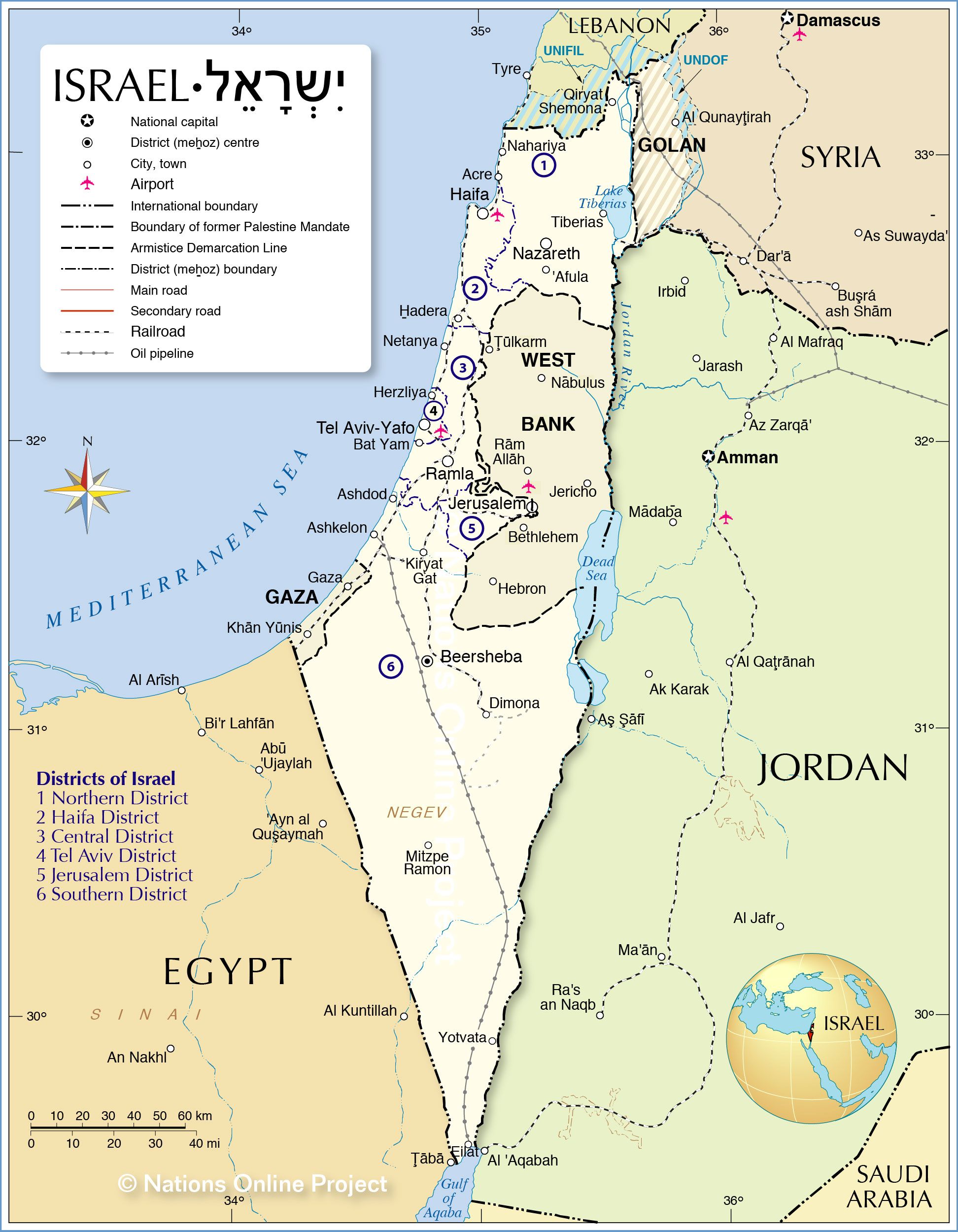
A few months ago, Al and I took a week-long trip to the middle and northern parts of western Jordan to visit three areas: Mount Nebo, Pella, and the Dead Sea. I’ve already blogged about the Dead Sea and Pella. Our last stop was Mount Nebo, the location most well known as the place where Moses died, then God buried him in the valley opposite Beth Peor. That’s really the only thing I connected with this peak.
My back-of-the-Bible maps taught me nothing about the terrain and surrounding areas. As I’ve said many times, Jordan is not called “The Second Holy Land” for nothing. So many events from the Bible happened along the western side of this country.
In fact, if you cut off the middle and eastern two-thirds of the Hashemite Kingdom, you would still have the slice where most everything happens. The eastern half is uninhabitable desert. The large cities in the northwest corner are the population centers. Aqaba holds down the fort on the southern tip, and smaller towns are sprinkled in the mountainous western backbone of the nation. It is that spine I want to focus on in this blog.
Most of the wilderness Israel wandered through for thirty-eight years was in the area I’ve described above. As Al and I have driven some of the same routes, the Bible has come alive to us, seeing where the multitudes camped along their way to the land God promised Abraham.
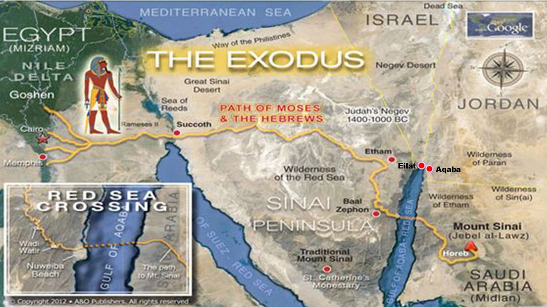
They left Goshen, traveled across the Sinai Peninsula, crossed the Gulf of Aqaba, and followed the cloud to Mount Sinai. After spending a year at the mountain and receiving the Ten Commandments, they headed north and went through Aqaba on the way. It was called Etzion Geber in the Bible. See my blog for more information about this town in Part 1 , Part 2 , and Part 3 of the history of the city we live in.
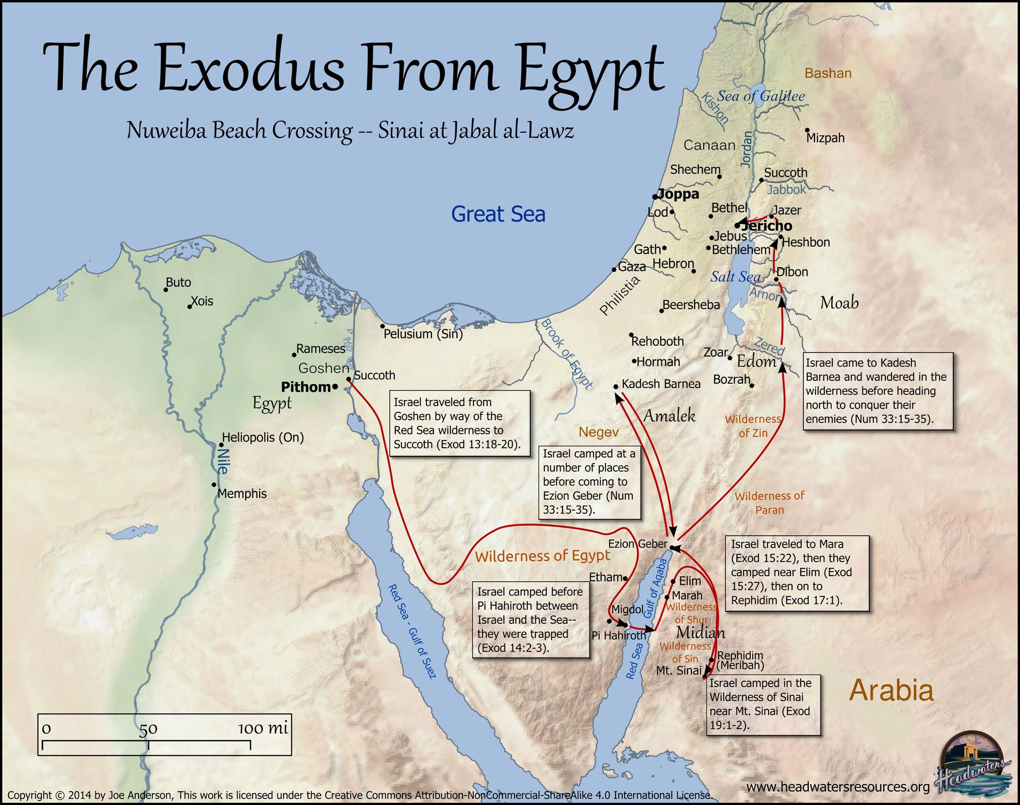
Here is a map showing the route the Israelites took to get to Mount Sinai. There is controversy about this, but I will write about what we have come to believe the wilderness wandering encompassed and where the places were likely located along the way.
In a future blog, I will tell how we believe when Yeshua returns, He will retrace the steps of the first exodus and come through here again. We’ll be watching for him from the rooftop of our apartment building if it’s within our lifetime. ;-D
Here is a probable route Israel took in the wilderness:
ABARIM MOUNTAINS
Chances are, you have never heard of the Abarim Mountains, so-named in the Bible. Today they comprise the border between Jordan and Israel, running along the Jordan Valley and the Dead Sea. In Hebrew, the word Abarim (ah-ba-REEM) means, “Those on the other side [of the Jordan River].” It comes from a Hebrew word, ever (long a-VAIR), meaning “one who crosses over.” In fact, the word Hebrew itself comes from this same three-letter root. Abraham was the first Hebrew. He crossed from Ur to the land where God directed him.
The northern part of the range is called Pisgah (meaning, a cleft) with Mount Nebo as the highest peak (2,330 feet above sea level). You’ve probably heard those names since they are connected with Moses. Keep in mind, the Dead Sea just to the west is 1,410 feet below sea level.[1]
When the people of Abraham lived in Canaan, before they went to Egypt to sojourn, they spoke of the region east of the Jordan as "beyond Jordan." Looking across the river and the Dead Sea, they designated the mountain country they saw there as "The Beyond Mountains." They continued to use these geographical terms when they came out of Egypt. There is no information telling us where the range began and ended.[2]
It was not until we moved here and began exploring the countryside that I realized the extent of the topography. Here is a fascinating cross section of the Jordan Valley between Israel and the ancient land of Ammon, Moab, and Edom.
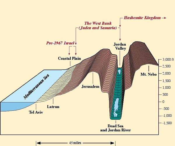
It’s easy to see where the high country is the admonition Yeshua gave those in Judea to flee to the mountains when they see the abomination that causes desolation standing in the holy place (Mark 13:14). The mountains on the east side of the river are definitely higher than those in Israel. They are within the ancient territory of Moab and the tribe of Reuben.[3]
You may remember the names of the Yarmouk, Jabbok, and Arnon Rivers from Scripture. Today, they are called the Yarmouk, the Zarqa, and the Wadi al-Mujib. They form the boundaries for three main portions in the highland/mountains of Jordan. The nations of Ammon, Moab, and Edom used these same boundaries in ancient times.
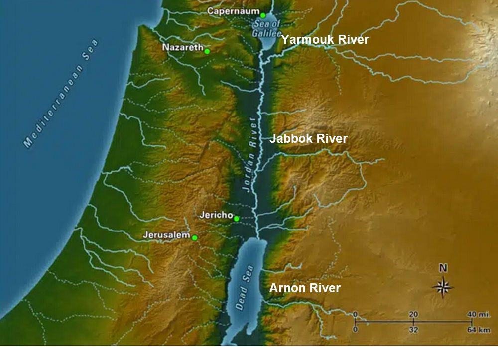
Yarmouk and Zarqa are tributaries of the Jordan River, and the Arnon empties into the Dead Sea. Madaba (MAH-dah-bah), which I will write about in Part 2, is the largest city in this land of Moab.[4]
The southern portion’s largest city is Karak (KA-rak) near the end of the Dead Sea. The rose city of Petra is also in this portion of the highlands.[5]
Several things happened in these areas.
· Balaam, of talking donkey fame, blessed Israel the second time from the top of Mount Pisgah. (Numbers 23:14)
· God allowed Moses to survey the Promised Land from the top of Pisgah. (Numbers 27:12 and Deuteronomy 3:27; 32:49), and there he died (34:1,5)
· The Israelites had one of their encampments in the mountains of Abarim after crossing the Arnon (Numbers 33:47-48).
· The prophet Jeremiah linked it with Bashan and Lebanon as locations from which the people cried in vain to God for rescue ( Jeremiah 22:20)
· Jeremiah hid the Ark of the Covenant there, according to 2 Maccabees 2:4-5. (The book of 2 Maccabees is included in Bibles used by Roman Catholics but generally not in Protestant or Jewish Bibles.)[6]
NEBO AND PISGAH
We headed toward Madaba on a modern four-lane, divided highway from our visit to the ruins of Pella in the north.
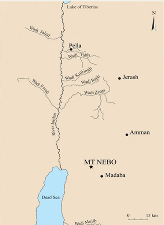
Our GPS said Mount Nebo was only fifteen minutes outside the city of 122,000. That’s if you know where you’re going, and we didn’t. We got lost in the maze of one-way streets but finally fought our way out of town headed in the right direction. GPS didn’t know which way the streets were going either. I doubt Moses had as hard a time as we did.
Madaba was contemporary with Israel’s wanderings. The Bible mentions it in telling how the Chosen People defeated King Sihon (see-KHOHN) of Moab:
Woe to you, O Moab! You are undone, O people of Chemosh! He has made his sons fugitives, and his daughters captives, to an Amorite king, Sihon.
So we overthrew them; Heshbon, as far as Dibon, perished; and we laid waste as far as Nophah; fire spread as far as Medeba. Numbers 21:29-30 (ESV)
Of course, on our trip, Nebo’s peak did not look like it did the day God showed Moses the land. For one thing, there is a church, museum, and monastery there, only excavated in the 1930s. For another, it’s almost always hazy. You can barely see the nearby Dead Sea, much less the Mediterranean or the entirety of the land. I believe God supernaturally showed Moses all the land he promised Abraham, much larger than modern-day boundaries. On a clear day, Jerusalem is visible, but the Mediterranean is roughly sixty-eight miles as the crow flies, and you simply cannot see that far, much less Dan in the north and the Negev in the south.
The Bible says:
Then Moses went up from the plains of Moab to Mount Nebo, to the top of Pisgah, which is opposite Jericho. And the Lord showed him all the land, Gilead as far as Dan, all Naphtali, the land of Ephraim and Manasseh, all the land of Judah as far as the western sea, the Negeb, and the Plain, that is, the Valley of Jericho the city of palm trees, as far as Zoar.
And the Lord said to him, “This is the land of which I swore to Abraham, to Isaac, and to Jacob, ‘I will give it to your offspring.’ I have let you see it with your eyes, but you shall not go over there.” Deuteronomy 34:1-4 ESV
That’s a lot of territory. It seems to me God showed him something supernatural. Remember, at that time, Israel had not crossed into the land. The people had not yet settled into their tribal allotments. They had taken a census, but technically, there was no designation of Dan, Naphtali, Ephraim, etc.
“What God allowed Moses to see wasn’t just a bunch of dirt and rocks. It wasn’t the cities of enemies or the struggles and battles that lay before the Hebrew people. Instead, God allowed Moses to see the land as it was promised and would be, a land belonging to the tribes of Israel, rich with food and water and livestock and massive in its dimensions. He allowed him to see their earthly home.”[7]
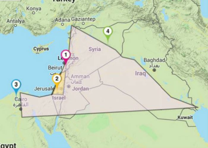
On the map below, the numbers indicate:
1 – Dan
2 - Be’er Sheva
3 – Nile River
4 – Euphrates River
There are different phrases in the Bible used to describe the boundaries God set out for the land of Israel.
From Dan, the northernmost city in the land, to Be’er Sheva, the southernmost
From the river of Egypt (Nile) to the great river Euphrates
According to Rabbi Menachem Leibtag, “the Nile and Euphrates represent the two centers of ancient civilization, Egypt and Mesopotamia. By saying the land between these two bodies of water is set aside for the children of Israel, God is implying that it is Israel’s destiny to become a blessing to all mankind by declaring His name at the crossroads of the two great centers of civilization.”[8]
During Solomon’s reign, the kingdom of Israel was at its peak and included parts of modern-day Egypt, Jordan, and Syria.[9] But it will not reach its full size until all the tribes return home.
Next time, I’ll write more about our visit and attach a video showing the pictures we took. It was an unforgettable experience.
Meanwhile, here is a link to a short video Al shot on our trip. I'll send a longer version to our paid subscribers. The first part of this video is an interview with a young woman.
We were enjoying the visitors' center La Storia near Mount Nebo and were looking at the first equipment to make toilet paper that was brought to Jordan in the 1950s, when a couple strolled by. The young woman said, "I am related to someone who runs this company."
Of course, Al started asking her questions and asked if he could film her. Enjoy.
[1] https://thenotesaregood.com/tag/can-you-see-what-moses-saw-from-mt-nebo/. Accessed 07/09/23
[2] Willis J. Beecher, International Standard Bible Encyclopedia
[3] According to the Catholic Encyclopedia (1913), the Hebrew Avarim appears in both the phrase har Ha-Avarim"mountain Abarim," and harei Ha-Avarim, "mountains of Abarim."
[4] Cheyne and Black (1899), Encyclopaedia Biblica,"Abarim."
[5] Catholic Encyclopedia (1913) entry for "Abarim."
[6] https://en.wikipedia.org/wiki/Abarim. Accessed 07/03/23
[7] https://catholicstand.com/a-leaders-view-from-mount-nebo/. Accessed 07/09/23
[8]https://theisraelbible.com/biblical-boundaries-land-israel/. Accessed 07/09/23
[9]Ibid., theisraelbible.com